Romsey Structure Plan skittles environment, local food and lifestyle objectives – Why it should be returned to authors for further investigation
By Patrick Francis
Summary: The June 2023 Draft Romsey Structure Plan is a watershed document with far-reaching and permanent negative consequences for farm land use, nature restoration and combating the declared Climate Emergency if not significantly amended. It ignores the views of world climate and nature organisations and the Shire policies in particular Carbon Neutral 2030, Climate Emergency declaration, Net Zero Emissions 2050 and Biodiversity Strategy. It also fails to recognise its impact on its potential for continuing local food production. Importantly for residents the Plan fails to meet their overwhelming expectations around living in a rural town with accessible connections to a healthy and biodiverse environment that improves their quality of life while contributing to solving the climate and biodiversity emergencies facing Australia and the world.
This submission to the Macedon Ranges Shire Council identifies seven key issues that need to be reconsidered by the authors before the Plan is submitted to Council.
Issue 1: Community feedback ignored
The June 2023 Draft Romsey Structure Plan ignores feedback from community consultation where the majority of respondents advocated for Option 1 (from the Emerging Options Paper 2022) which limits future development to within the existing town boundary.
Even the authors of the June 2023 Draft Romsey Structure Plan states this on page 14: “Expansion of the existing settlement boundary was met with concern, with the majority of respondents preferring ‘Option 1’ to contain development within the boundary, as opposed to Options 2 and 3 from the Emerging Options Paper, which were received with apprehension. The loss of farmland (adjacent to the town) was of concern for respondents as they feel it may threaten their livelihoods and the surrounding landscape character.”

Figure 1: Majority community feedback from the Romsey Structure Plan Emerging Options Paper 2022 rejected any development outside the existing town boundary, yet the authors of the June 2023 Draft Romsey Structure Plan have ignored that advice and propose 7 Investigation Areas outside of the existing town boundary and contend 5 are viable for development. Image source: June 2023 Draft Romsey Structure Plan
Yet the authors ignore this community feedback and state “…while the existing town boundary could support additional residential, commercial and industrial growth, there was need for expansion to the town boundary to enable realistic and viable development in the township.”
The authors do not explain why Option 1 is unrealistic for Romsey township development or why their opinion of what is realistic or not carries more weight than the opinions of residents who favour Option 1.
The authors propose seven investigation areas, figures 1, outside the existing town boundary and are suggesting Councillors vote to accept these. In other words the authors of the June 2023 Draft Romsey Structure Plan are asking councillors to ignore the majority community feedback from 2022 which does not want development outside the existing town boundary.
Issue 2: Plan criteria misleading
The criteria under which the authors scored each Investigation Area, figure 2, are nothing more than opinion as there is no data provided to substantiate the scores. In some instances, the authors opinions are misleading. For example, Criteria 1 assesses how development within each area is consistent with existing Council strategic directions and policies. But development particularly housing is a major contributor to greenhouse gas emissions (20% of the nation’s total) and subsequently climate change. Yet on 24 March 2021 the Macedon Ranges Shire Council declared a Climate Emergency as a core principle and policy basis for corporate planning and decision making. Given the authors have not mentioned the Climate Emergency in the Draft Strategy, they have made a decision to ignore it or believe it is not a core principle or policy for decision making.
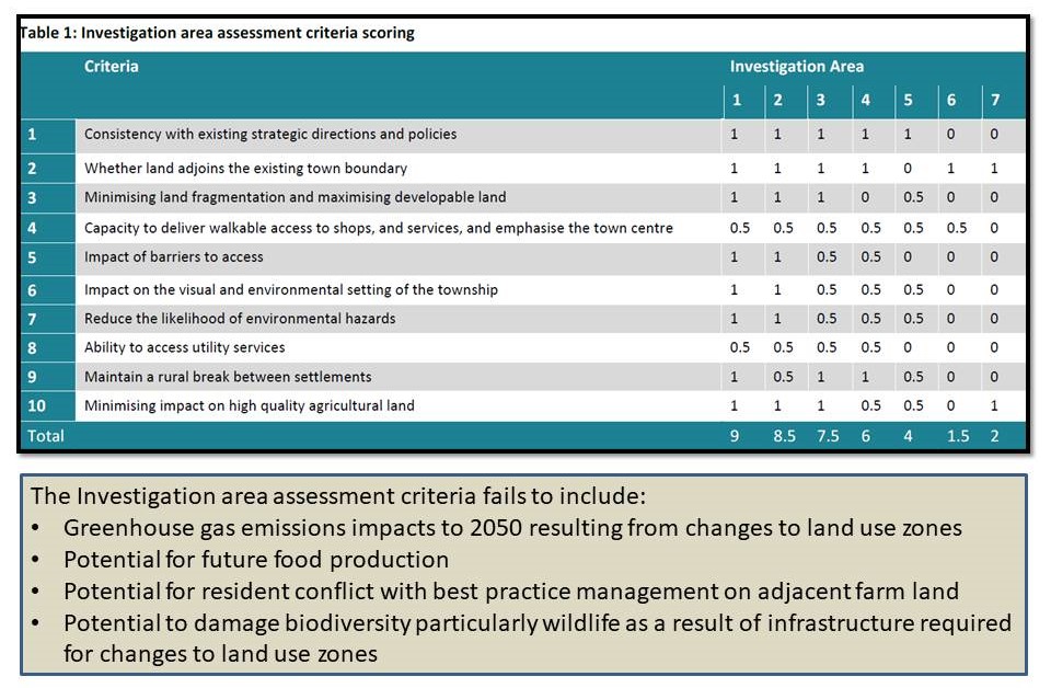
Figure 2: The Investigation Area Assessment criteria are misleading as the draft Strategy fails to provide any data to back the ratings given for each area or define what ratings 1, 0.5 or O mean in terms of outcomes. They are the authors’ opinions not facts. Of particular concern is the apparent conflict within Criteria 1 which covers consistency with Council’s existing strategic directions and policies yet on 24 March 2021 the Macedon Ranges Shire Council declared a Climate Emergency as a core principle and policy basis for Council’s corporate planning and decision making. Development in all Investigation generates significant greenhouse gas emissions and contributes to anthropogenic climate change. Source: Top table June 2023 Draft Romsey Structure Plan, Lower table Patrick Francis
Issue 3: Sustainability greenwash without details
Rather than estimate emissions from construction and annually per household built across Precinct 5 (Investigation Areas 1, 2, and 3) the authors use greenwash speak in Strategies 22 and 23. Terms such as “investigate options”, “continue to advocate”, “explore opportunities” , “climate change in mind”, “healthy urban forest”, “contributes to biodiversity conservation”, “water sensitive urban design”, extoll a wish list with no actual detail around how the additional greenhouse gas emissions will be reduced and how Net Zero Emissions by 2050 will be achieved.
If such wish list had validity of actually happening it would be anticipated that there are more obvious design guidelines in Figure 14 for Precinct 5 to accommodate:
* A healthy urban forest – this means sowing eucalypt species at around 600 stems per hectare in 100m or wider buffers across and around the precinct – no indication of this in Figure 14.
* Biodiversity conservation biolinks again will be a minimum of 100m wide. This is indicated only for Five Mile Creek which does not enter Precinct 5. The other biodiversity/riparian zone vegetation in Figure 14 is mostly indicated to happen on privately owned farm land outside the existing town boundary and proposed town boundary. Some landowners have already undertaken this revegetation along Dry Creek and have connected biolinks to the riparian zone. There are no proposed riparian and biodiversity buffers along drainage lines shown in Figure 14 through Precinct 5. These should be in place for drains across Precinct 5 into Dry Creek and at least two into the Buffer Area and eventually to Deep Creek.
The lack of inclusion of these biodiversity biolinks and riparian biolinks suggests the authors ideas are aspirational only and will never be introduced.
Issue 4: Failure to analyse house building potential within the town boundary
A glaring omission in the June 2023 Draft Strategy for Romsey township is failure to investigate the potential for further development of social, affordable and conventional housing across Precinct 3 within the existing town boundaries. Most house blocks within Precinct 3 are of considerable size based on historical subdivision of 3000 to 7500 square meters (m2). Figure 3A and 3B are two typical blocks within Precinct 3 which highlight the enormous potential for increasing the number of houses within the boundary with minimal requirement for new infrastructure such as roads, footpaths, water, gas, electricity and sewer supply.
Given some large house blocks have been and are in the process of being developed with high density housing (6 to 12 units) where previously one house existed, with changes to the zoning rules Romsey has the potential to accommodate within its existing boundary an additional 1500 – 2000 houses of different types and densities including social and affordable housing, figures 3A and 3B. Without expensive infrastructure as is required for the greenfield P5 precinct site outside the existing town boundary, such housing will be more cost effective and will minimise construction greenhouse gas emissions, figure 3C.
Organic growth of higher density house construction within Precinct 3 means impacts are gradual and lifestyle desires of existing residents as voiced in community meetings can be maintained. It gives Council time to gradually develop the town sewerage, employment and transport infrastructure currently lacking to meet the needs of an increasing Romsey population.
The Draft Structure Plan authors have made no attempt to calculate the potential number of higher density houses that could be built in Precinct 3 over the next 20 years. To the contrary the authors are promoting urban expansion across Precinct 5 which is currently a farming zone with “a variety of lot sizes across the subdivision including 600 sqm (40%), 850 sqm (40%) and 1500 sqm (20%) lots with greater density such as townhouse development adjacent to parks and reserves”.

Figure 3A. In the north east section of Precinct 3 house blocks are mostly in excess of 7000m2 and with time many could be subdivided to accommodate higher density housing.
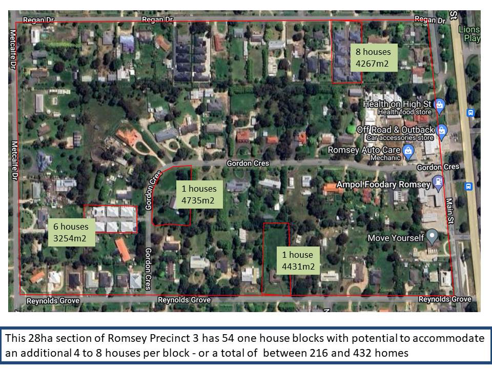
Figure 3B: In the ‘older’ part of Precinct 3 most house blocks are in excess of 4000m2. A trend is emerging to subdivide these blocks for up to eight higher density houses.

Figure 3C: As house blocks in Precinct 3 are sold developers are taking the opportunity build higher density, higher profit housing with some blocks accommodating eight new homes where previously there was one. The infrastructure and tree scapes already exist, Top. The authors of the Draft Plan have made no attempt to model how this approach could meet the population increase objective over the next 20 years without resorting to expensive development of the greenfields Precinct 5 where the entire infrastructure associated with housing has to be constructed, Below. Photos: Patrick Francis
.
Issue4: Plan adds more emissions causing climate change
Given climate change is considered by the Shire as a “Climate Emergency” not to include any reference to how the Romsey Structure Pan will contribute to greenhouse gas emissions means the plan must be reconsidered if it is to have any credibility for sustainability and resilience as chapter 9 maintains.
The Shire has a declaration on its web site which states: “Council joined over 30 councils in Victoria and almost 100 councils across Australia in passing a motion at its Council Meeting on 24 March 2021 to declare a Climate Emergency.
“The declaration recognises the urgent need to address the causes and impacts of climate change across all aspects of Council’s operations, and in its work with the community.
“It provides a core principle and policy basis for Council’s corporate planning and decision making, and also sends a message to the wider the community that climate change is the key priority to address in all sectors of society.”
Housing is an important contributor to climate change, through resource use for building and on-going occupation.

Figure 4: Household greenhouse gas emissions are dominated by transport and in the Romsey Structure Plan if the town boundary is expanded this component is likely to increase for within town travel as well as outside town travel for work and recreation.
According to Carbon Positive Australia which promotes generating offsets for urban greenhouse gas emissions the average Australian household (2.6 people) has an annual carbon footprint of approximately 15-20 tonnes of CO2e. According to the UN, to limit global warming to 1.5 degrees Celsius by 2050 we must limit our per-person emissions to 2 tonnes CO2e per year. That means if you have a family of 4, for example, you should be aiming for 8 tonnes CO2e per year.
There is no data about emissions generation as a consequence of new housing development in Precinct 5. However, if it goes ahead with potential of 2000 new homes, total annual emissions on completion based on current household data suggests an additional 30,000 to 40,000 tonnes of CO2 will be emitted annually. Those emissions exclude all the housing development and construction emissions generated developing Precinct 5, as shown in Figure 3C.
Carbon Positive Australia notes that there are co-benefits for the environment with offsets which are relevant to Investigation areas 1, 2, 3, 4 and 5 in the Romsey Structure Plan if they are retained for holistic farming.
“Your offsets help to fund our range of high quality, native restoration projects. Our planting projects not only sequester carbon but also restore Australia’s habitat and natural biodiversity. Where possible, our projects follow methodologies developed by the Australian Government’s Emissions Reduction Fund (ERF). Several of our projects are also registered with the ERF.”
The irony here is the Macedon Ranges Shire Council will be looking to purchase CO2 offsets through the ERF to meet its own carbon neutral status policy and net zero emissions by 2050 policy. It recently partnered with the North Central Catchment Management Authority to investigate generating revegetation carbon offsets on farm land.
The opportunity to generate carbon offsets exists outside the current Romsey town boundary if the correct incentives are put in place with landowners. The current land-bank and developer owners in Investigation areas 1,2,3,4 & 5 have no incentive to generate revegetation ERF projects as their interest is totally based on profit from housing development. So not only do the land-bankers and developers deny the shire of the opportunity to encourage farming zone land for greenhouse gas abatement, their housing developments add more greenhouse gases to the atmosphere.
So how does Macedon Ranges Shire Council reconcile removing 394 hectares of farming zone land around Romsey in the June 2023 Draft Romsey Structure Plan with its Climate Change Action Plan and its response to the Climate Emergency which “recognises the urgent need to address the causes and impacts of climate change across all aspects of Council’s operations, and in its work with the community”?
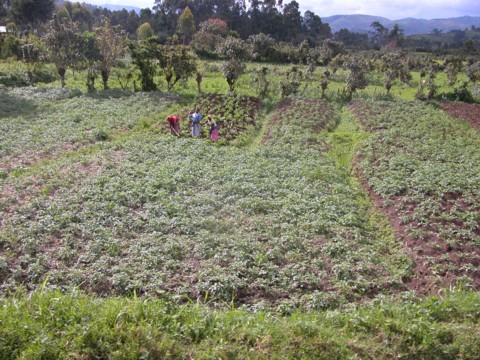
Issue 5: Potential food production opportunity lost forever
As for potential for food production in the Investigative areas 1, 2, 3, 4, and 5, the Council’s 2020 Farming Zone Review stated: “Agriculture
− Ensure settlement avoids areas of productive agricultural land or land with potential for agricultural production
− Protection of productive agricultural land and promotion or agriculture and other rural industries
− Facilitate investment in new opportunities and high value agriculture.”
Given these statements the fact that the June 2023 Draft Romsey Structure Plan gives no consideration to the loss of potential food production across Investigative Areas 1, 2, 3, 4 and 5 proposed for residential zoning, is an important omission and calls into question the Council’s previously stated intentions for agriculture.
The June 2023 Draft Romsey Structure Plan authors have not taken agriculture into account or consulted with agricultural scientists about the potential for food production across Investigation Areas 1, 2, 3, 4, and 5. There are no references within the document about how potential food production per hectare relates to soil quality criteria (such as structure, water holding capacity, organic carbon and pH) and growing season rainfall in these five Areas.

Figure 5: Investigation Areas 1,2, 3, 4 and 5 embrace high quality basalt clay loam soil with an average 700mm rainfall. Farm land with such characteristics in a region where climate change impacts to 2070 are minimal on rainfall must be protected for food production and biodiversity enhancement. Sources: Image: June 2023 Draft Romsey Structure Plan; comment box Patrick Francis.
To ignore local food production possible on Investigation Areas 1, 2, 3, 4, and 5 demonstrates the authors have no vision around future food supply and its connection with countering climate change. While food supply is currently not an issue the further away from consumers’ food is produced and processed the greater the emissions generated and the higher its cost. An indirect cost of food will become more apparent as the nation heads toward 2050 as farmers, wholesalers and retailers are required to purchase carbon abatement to meet their net zero emissions regulations.
In the promotion for its 2023 Future of Food webinar the University of Melbourne stated “In a wealthy country like Australia, it is easy to take our food security for granted. But climate change and other environmental and political and economic trends could make food insecurity an issue for all people on Earth, including in Australia. The recent release of the Federal Government’s new intergenerational report identified the impact of climate change and net zero transformation on food security as one of the challenges that will shape Australia over the next 40 years.”
As the authors of the Draft Romsey Structure Plan make no reference to the future consequences of removing 394 hectares of high quality soil, high rainfall farming land from production, they disagree that food security is one of the challenges that will shape Australia over the next 40 years.
An autumn 2023 investigation into food basket cost by the Healthy Loddon Campaspe Group found a basket of locally grown food was similar in price to the same products purchased from a large supermarket. Of particular relevance to residence across Macedon Ranges Shire was that “Out of a total of 1802 audited fruit and vegetable items, just over 5% were locally grown, while around 16% originated from elsewhere in Victoria, almost 74% were sourced from other parts of Australia, and approximately 3% were grown internationally.
“In contrast, locally grown produce was predominantly found at local farmers markets (35.4%), followed by greengrocers (32.3%) and small supermarkets (32.3%)”.
Healthy Loddon Campaspe Coordinator, Alicia O’Brien said that the research results highlight the importance of creating a thriving local food system.
“Our research emphasises the need for increased advocacy and efforts to establish a local food supply chain, as well as to shift consumer perspectives towards understanding the health and environmental advantages of locally grown produce, without incurring additional costs.
“In addition to the research findings that purchasing locally grown produce is no more expensive than food grown outside the region, there are also additional benefits associated with consuming locally grown produce, such as reduced food miles, support of local retailers and farmers, fresher produce, and the ability to eat seasonally”.
These findings highlight how inadequately the authors of the June 23 Draft Romsey Structure Plan have analysed the consequences of removing 394 hectares of farming zone land from production given there is opportunity for considerably more housing within the existing town boundary without venturing outside of it.
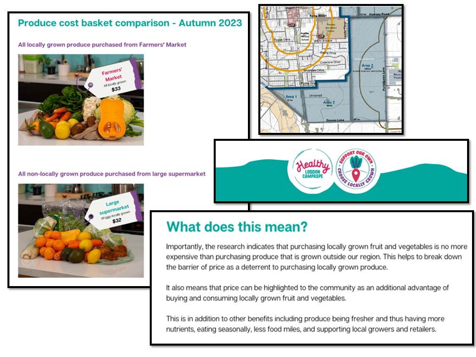
Figure 6: Research into locally grown food available at Farmer Markets and small shops shows it costs no more than food imported from around Australia yet it has lower food miles and generate lower greenhouse gas emissions. Such information has been ignored by the authors of the June 2023 Draft Romsey Structure Plan who are recommending removal of 394 hectares of high quality soil, high rainfall, farming zone land for residential development. Source: Healthy Loddon Campaspe Group.
Issue 6: Nature enhancement ignored
An important omission in the June 2023 Draft Romsey Structure Plan Figure 10 is failure to include biodiversity biolinks around the existing town boundary where it abuts with Investigation areas 1, 2, 3, 4, and 5. The majority of residents claim they move to Romsey to experience living in a rural environment with opportunity to experience and interact with biodiversity in forms of plants and animals. Currently the principle walking or bike riding opportunity for Romsey residents to come close to nature and biodiversity is to leave the town boundary and take the Knox road, Moffats lane, Black Range road, Kerrie road circuit, figure 5.

Figure 7: The only marginally safe place for Romsey residents to experience local nature and biodiversity is on the Knox road, Moffats lane, Black Range road, Kerrie road circuit west of the town boundary where local farmers have planted biodiversity biolinks along their road boundaries and through their properties as part of the Land for Wildlife initiative. Photos: Patrick Francis.
In contrast the developer/land banker owned land in-between Knox road, Greens lane, Portingales lane and Wallan road surrounding Investigative areas 1, 2, 3, has been unmanaged for biodiversity improvement and agriculture for the last 20 to 30 years. No biodiversity biolinks have been planted, in what can only be described as an environmental waste land bordering approximately 50% of the existing Romsey town boundary.
The June 2023 Draft Romsey Structure Plan authors offer no vision to change this situation. At the very least the Plan should have included a 100m wide biodiversity biolink adjacent to the existing town boundary along Investigative areas 1,2,3,4, as well as along Knox road, Greens lane, Portingales land and Wallan road, figure 6. The biodiversity biolinks along Knox road will create a connection to biolinks already put in place on private farm land to the south west of Romsey and inturn to the Macedon Ranges. This would give Romsey residents the opportunity to experience nature’s biodiversity at their town boundary and ensure the lifestyle they moved to Romsey for is delivered in perpetuity.
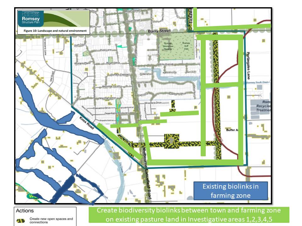
Figure 8: The Draft Plan authors failed to include Biodiversity biolinks between the existing and proposed town boundary and the farming zone in sections where open pasture currently exists. Image source: Figure 10 June 2023 Draft Romsey Structure Plan with 100m wide biodiversity biolink additions by Patrick Francis
The authors of the June 2023 Draft Romsey Structure Plan may consider the return of biodiversity biolinks as suggested in Figure 7 as radical, but it is what society’s around the world are calling for. A recent initiative called Nature Positive is being backed by high profile international companies and NGOs to halt and reverse biodiversity loss by 2030, figure 9A.

Figure 9A: World organisations are backing the Nature Positive initiative to reverse biodiversity loss by 2030. Macedon Ranges Shire Council acknowledges biodiversity loss across the shire yet is prepared to sacrifice 394ha of farming land to housing development rather contain development within the existing town boundary and use the farming zone land in Investigation areas 1, 2, 3, 4, and 5 to restore biodiversity, offset greenhouse gas emissions and facilitate local food production.
According to Marco Lambertini, Convenor of the Nature Positive Initiative “Reversing biodiversity loss is finally recognised as essential to safeguarding planetary health and, in turn, the future of humanity. The Nature Positive Initiative aims to bring together a multitude of organizations from different sectors to preserve the integrity and the ambition of a 2030 nature positive global goal, broaden adoption, and guide and encourage measurable action. The historic agreement of the Kunming-Montreal Global Biodiversity Framework must be the focus and catalyst for action from all sectors so that by the end of the decade we will have more nature in the world, not less, for the world to be a safer place for all of us. Action is urgent to avoid irreversible ecological tipping points. Nature cannot wait, and neither can humanity”.
Jane Madgwick, Executive Director, Global Commons Alliance commented about the Nature Positive initiative that “Recent science indicates that there is a rapidly closing window of opportunity to secure a safe and just future for people and planet. Earth system resilience and human well-being depends on stepping up action urgently and through radical collaboration across companies, in cities, landscapes and countries, to protect and restore nature at scale”.
The Nature Positive initiative is not an academic wish list of ideas, it has been proven on farms starting just 200m outside the Romsey town boundary. Landowners who started planting biodiversity biolinks around and across their farms in the 1990’s are experiencing the exact outcomes that halt and reverse biodiversity loss predicted by Nature Positive, figure 9B. Not only has the native vegetation and wildlife been restored, the farms are net sinks for CO2, in other words the farms are providing CO2 abatement that the shire will be looking for to meet its net zero emissions 2050 target.

Figure 9B: Land for Wildlife farmers west of the Romsey town boundary have demonstrated that the Nature Positive initiative can produce real results and reverse biodiversity loss around Romsey while at the same time achieve greenhouse gas abatement in conjunction with producing local food. Sources: Graphic Nature Positive; satellite Google Earth; photos Patrick Francis.
HE Razan Al-Mubarak, UN Climate Change High-Level Champion for COP28 makes the connection between returning biodiversity to farm land and countering climate change. “The goals of the Paris Agreement can’t be met without nature. Our shared definition of ‘nature-positive’ is crucial for tackling both climate and biodiversity crises. COP28 (United Arab Emirates November – December 2023) should be the moment to refine the implementation of the Paris Agreement and enhance climate efforts by limiting emissions and restoring nature in a timely manner. All stakeholders must act now for a nature-positive, net-zero and equitable future.”
The connection between limiting greenhouse gas emissions and nature-positive actions have been ignored by authors of the June 2023 Draft Romsey Structure Plan. Their recommendation to develop Investigation areas 1, 2, 3, as a new housing precinct highlights how out of touch they are with world scientific thinking around solutions for halting climate change, enhancing nature and dealing with the climate emergency.
Issue 7: No nature buffers between farms and houses
The failure to provide a biodiversity open space buffer between the farming zone and residential development leaves open the door to potential “right to farm” issues between home owners and farmers. In other words best practice farming activities such as fertiliser application, herbicide and pesticide spraying, farm machinery use , animal husbandry practices (weaning calves and lambs), and feral animal control particularly shooting foxes and rabbits all become far more visible or noticeable, figure 10A. They have potential to generate dust, noise, smell which can bring residential home owners into conflict with farmers.
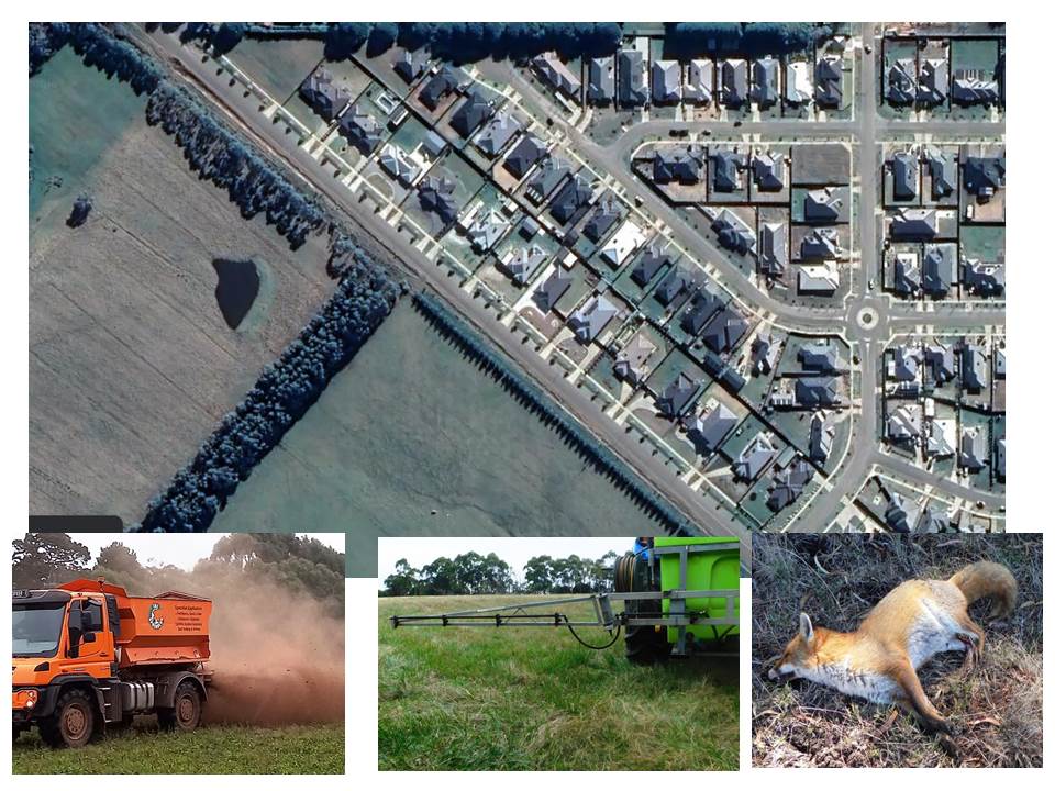
Figure 10A: The failure to include a 100m wide biodiversity biolink buffer zone along Knox road in the recently (2016 to 2020) built Lomandra estate means legitimate best practice farming activities such as fertiliser and manure spreading, herbicide and pesticide spraying, and feral animal control by shooting and baiting, can cause conflicts with home owners adjacent to the farming zone. Photos: Patrick Francis and Google Earth.
Figure 10B: The Lomandra housing development which started in 2016 is a classic example of planning failure to provide a significant biodiversity biolink buffer between residential housing (left) and farming zone (right) when the opportunity to do so along Knox road was available. Photos Patrick Francis.
The most recent example of the town planning failure to include a biodiversity open space buffer between the farming zone and residential development happened with the Lomandra Estate along Knox road. The residential blocks along Knox road should have been sited at least 100m in from the Knox road verge and the buffer so created planted with native vegetation, providing improved natural biodiversity and amenity for residents and minimising impacts for residents from the types of farming activities town residents might find unpleasant, Figure 10B.
Planning associated with potential future housing development on farming zone land close to Romsey has failed to confront land neglect for 20 to 30 years across the 233 hectares of Investigation areas 1, 2, and 3. Land banking or speculation should not be an excuse for neglect, figure 11. What is now the Lomandra Estate plus Investigation areas 1, 2 and 3 have been neglected on environmental enhancement and best practice agriculture grounds since the 1990’s in anticipation of planning rule changes to allow housing development. In contrast over the same period of time some landowners/farmers adjacent to the Lomandra estate and Investigation area 1 have planted biolinks which have achieved spectacular success returning wildlife including locally extinct species like wombats and sugar gliders and sequestering carbon in vegetation, figure 9B.

Figure 11: The June 2023 Draft Romsey Structure Plan bases new development across Investigation areas 1, 2, and 3, farming zone land that has been neglected by its speculator owners for decades. Photos: Google Earth and Patrick Francis.
Summary
If re-written with a vision to embrace solutions to lower greenhouse gas emissions, abate carbon dioxide, use nature to address the Climate and Biodiversity emergencies, and encourage local food production, the Romsey Structure Plan would provide a blue print for sustainable development within town boundaries across the shire and give resident families the life styles they move to the shire to experience. World views about how housing development is undertaken in conjunction with nature, biodiversity, CO2 abatement, climate emergency, biodiversity emergency, local food, low food miles, mental and physical health, quality of life, and landscape amenity give the direction it must go in, figures 11A and 11B.
Figure 11 A: What a nature rich housing development provides. Source: Wildlife Trust UK.
Figure 11B: 91% of Victorian parents believe it is important that their children spend time in nature. Source: Biodiversity 2037 Victorians Value Nature.