Shire’s Romsey growth options are missed opportunity to combat climate change and reduce greenhouse gases
By Patrick Francis
Macedon Ranges Shire Council recently released the Romsey Structure Plan (RSP) for comment and suggestion from rate payers. It presented three options and four scenarios for growth but in effect the outcome seems to be predetermined despite what rate payers may suggest. And that outcome for Romsey to become a “large district town, 10,000 people” will result in the production of more greenhouses gas and contribute to global warming.
It doesn’t have to be that way, just the opposite, with the minimum growth Option 1 there is an opportunity for the Romsey district to counter climate change by adopting land use change in the farming zone around the town which sequesters CO2 from the air and locks it up in vegetation, figure 1. In other words by adopting Option 1 Romsey’s development plan presents the shire with an opportunity to counter global warming by carbon abatement on surrounding farm land. No other towns targeted for growth in the shire have the same potential for CO2 abatement in the surrounding farming and rural living zones as Romsey.
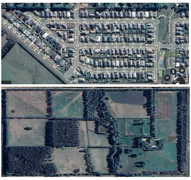
Figure 1: The Romsey Structure Plan takes no responsibility across the Options presented for greenhouse gas emissions driving the Climate Emergency. It fails to review emission outcomes of more residential housing developments on farming land versus land use change on the town’s surrounding farms to remove greenhouse gases from the atmosphere while at the same time producing food and fibre.
Despite the Council having environmental and greenhouse gas policies there is no connection made between housing development and population increase and their additional production of greenhouses gases and subsequently adding to global warming and the climate crisis. In fact the RSP does not mention global warming or greenhouses gases and mentions climate emergency once. The Council’s assumption here is that its environment and climate change policies are independent of increased greenhouse gas production associated with “State and Council Policy (which) identifies that Romsey will grow into a Large District Town.”
Such disparity between Shire policies and actual implementation plans is common. For instance its draft future Land Use strategy for the farming zone fails to include changing land use practices which ensure greenhouse gas abatement and biodiversity restoration, despite both practices being implemented by innovative, landcare orientated farmers in the Shire and across the nation. The Council’s assumption is that farming involves production of food and fibre not land uses that avoid greenhouse gas emissions and sequester CO2.
Another disparity is the Shire’s Biodiversity strategy which contends it is about protecting and enhancing local and threatened biodiversity yet fails to involve strategies to reduce the maximum 100km per default maximum speed on local minor rural roads under its control where wildlife are being killed and injured every day. The Council’s assumption here is that the road safety and management strategy is not part of biodiversity management strategy and the engineers managing the former do not take responsibility for wildlife and road kills. Similarly biodiversity staff have no say in road safety and management. The outcome is no department in Council accounts for or takes responsibility for road kills, so the deaths continue to increase as the shire’s population and tourism traffic increases, figure 2.
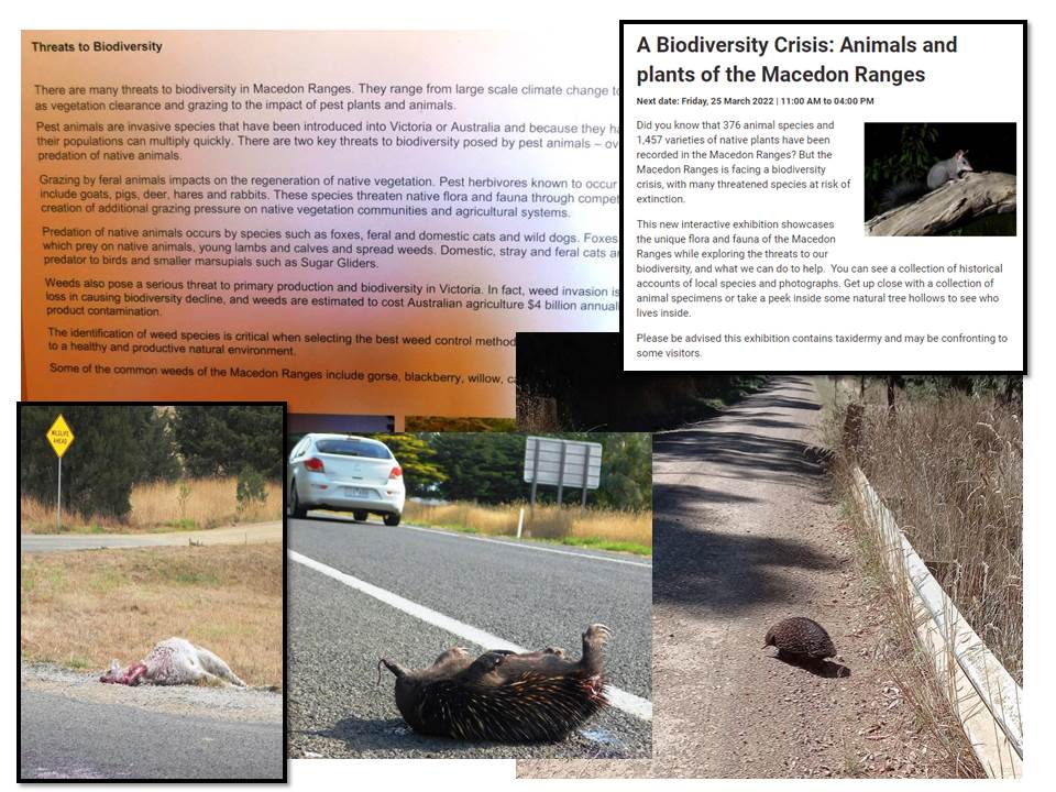
Figure 2: Macedon Ranges Shire Strategies enigma. Obvious solutions fall between the responsibilities of relevant strategies managers. A classic example. Rural roads management are the responsibility of engineers who have no responsibility for wildlife welfare. Environment staff have responsibility for wildlife welfare but not for rural roads. So wildlife is regularly killed by vehicles travelling at up to 100km per hour on these roads, but neither department seem able to act to change the situation. Interestingly the Shire recognises wildlife are under threat (top left) and there is a biodiversity crisis (top right), but an obvious and increasing cause – road kill is not nominated as a threat (top left).
Romsey Structure Plan
The background to the Romsey structure plan which suggests consultation with rate payers is a disingenuous process can be found in the Macedon Ranges Statement of Planning Policy (MRSPP). This “requires the Romsey Structure Plan to determine the future boundary of the township to guide development to 2050.”
But “according to the Macedon Ranges Planning Scheme (MRPS), Romsey is a developing township and is planned to grow to 2036 with an anticipated population at the cusp of a district town (6,000 people) and a large district town (10,000 people).”
In a community Q & A paper produced after a public town meeting to provide answers to questions from residents, town planners repeated a response five times which was:” State and Council Policy identifies that Romsey will grow into a Large District Town. This has recently been reaffirmed through Council’s endorsement of the Macedon Ranges Statement of Planning Policy in 2019 and State Government approval in late 2019.”
The planners also stated: “The options outlined are only options and are not recommending or promising set outcomes.”
These are contradictory statements. Romsey cannot “grow into a large district town” unless options 2 or 3 or scenario 4 or a combination of all three are adopted.
Three Options and four Scenarios are presented in the paper. The differences between Options and Scenarios are not explained, but figures 25 and 33 demonstrate that only Scenarios 3 (Option 3) and 4 are likely to meet the Macedon Ranges Planning Scheme requirement, figure 1. Scenario 1 (Option 1) and most likely Scenario 2 (Option 2) are already irrelevant. Scenario 4 is not included as an Option 4, so what is it?
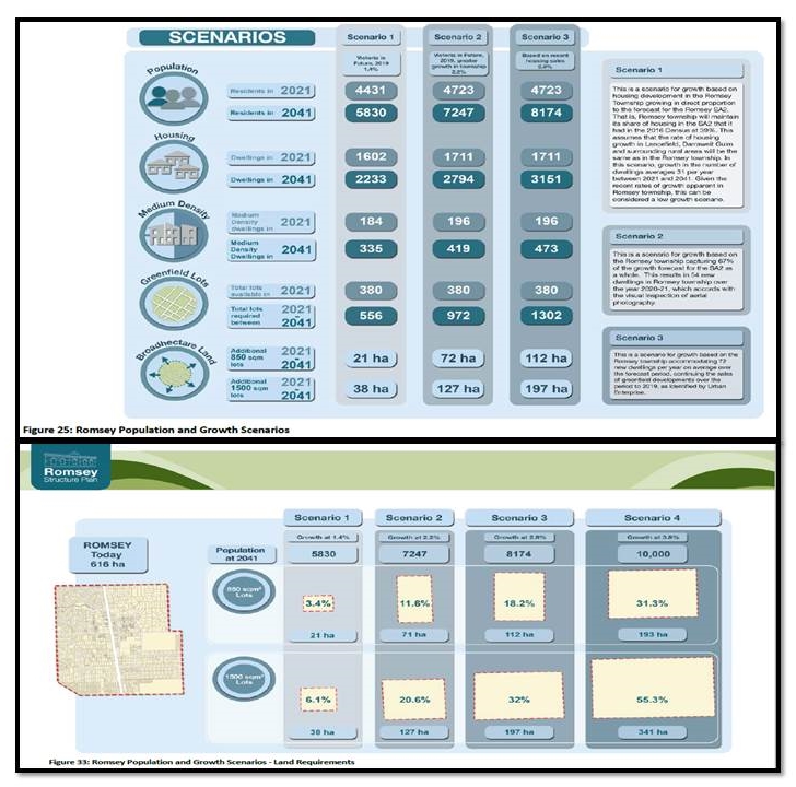
Figure 3: Only Scenarios 3 and 4 are likely to suit the already decided Macedon Ranges Planning Scheme. Scenarios 1 and 2 are not true Options for the Scheme, leaving Scenarios 3 and 4 as possibilities but no economic, social or environment performance assessment was included in the RSP for rate payers to consider.
My submission
My submission to Council reviews the Options paper under six headings:
- Has the Draft Structure Plan outcome already been decided?
- Legacy of new housing developments not addressed.
- No context given to housing development in other shire and neighbouring towns.
- No reference to regional roads infrastructure.
- Insufficient data around implications of Options contribution to global warming and climate change.
- Protecting agricultural land to counter global warming not addressed.
For the sake of brevity I include the details for points 5 and 6.
Insufficient data around implications of Options contribution to global warming and climate change
It is difficult to understand why the proposals around increasing Romsey’s population in Options 2 and 3 and Scenario 4 are not accompanied by an extensive review of their impact on global warming and climate change in this Climate Emergency era. The Macedon Ranges Shire has announced policies for net zero emissions by 2030 but fails to provide any data about how each of the three Options and Scenario 4 will contribute to emissions or alternatively avoid emissions.
There are two aspects to achieving net zero emissions, firstly limiting population growth and secondly protecting land and ecosystems from housing development so greenhouse gases can be abated and local environment restored.
Any increases in population anywhere will automatically increase emissions irrespective of the use of renewable energy sources.
In their “Population and Climate Change” discussion paper Ian Lowe et al state: “Do we treat population growth as ‘just something that is happening over which we have no control, and accept the consequences whatever they may be? Or do we look at ways to influence the rate of population growth so that we are more likely to get the outcomes we desire? The latter approach is what we will call ‘population policy’. This is a way to treat population growth as a policy-relevant variable which, to some extent, is amenable to conscious influence at the societal level even while enhancing individual choice and autonomy.”
Furthermore they state: “All governments have the option to use population policy to help reduce greenhouse gas emissions, either by minimising further population growth or supporting its gradual decline.”
The draft RSP states on page 45 that: “Council’s 2021 Environment Strategy builds on the original strategy providing direction on climate emergency, sustainable transport… These include promoting climate change action and renewable energy generation.” Importantly, Council’s Environment Strategy does not include a shire wide town population policy which is the strategy of most importance when it comes to reducing greenhouse gas emissions and combating climate change.
The RSP’s four population and growth scenarios in figure 33 and tables 2, 4 and 6 give no estimates of greenhouse gas emissions that will be generated directly through infrastructure development (housing, roads, sewerage, water supply etc.) and ongoing through energy requirements (domestic power, fossil fuels for vehicles etc.).
In fact Scenario 4 has no environmental assessments made in the Draft plan as happens with Scenarios 1,2, and 3, despite the fact is provides for the greatest population increase and requires the most amount of land to be removed from farming, figure 4.
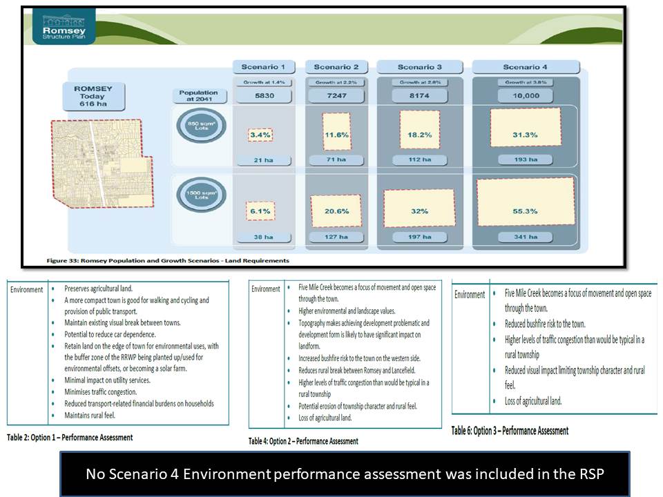
Figure 4: There are four Romsey population and growth scenarios but there are no details or assessments provided for Scenario 4 despite it requiring the largest amount of land to accommodate the greatest increase in population.
If the Council has no estimates of the impact of the four population growth scenarios on greenhouse gas emissions for Romsey how can it make decisions around “climate change action”? For instance new housing can be powered with grid connected electricity and gas or with local renewable energy with each new house generating electricity with solar panels and feeding excess power into a local battery bank owned by the local residents.
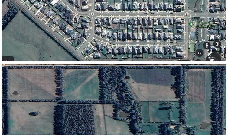
The second component of combating climate change which is particularly relevant to the RSP is how land use in the surrounding farm zone is developed with a focus on carbon sequestration and reduced emissions. Up to 341ha of farm and rural living zone land have been designated for potential development outside the existing Romsey town boundary. Given its high quality soils, medium to high rainfall, and low impact of climate change on weather, this farm land has enormous potential for sequestering CO2 in vegetation and restoring lost and diminishing biodiversity as well as providing other ecosystem services forever. Alternatively the same area can become a net emitter of greenhouse gases through development and population and provide nothing towards improving biodiversity and ecosystem functions, figure 5.
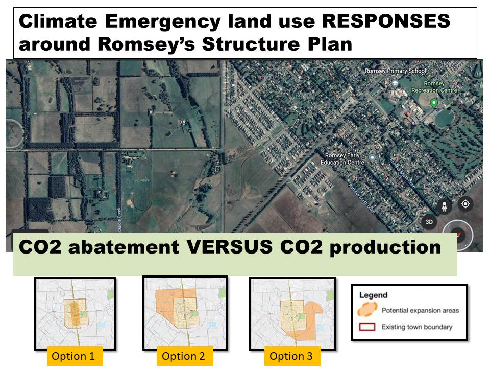
Figure 5: All the farming zone and rural living zone land around outside the current Romsey town boundary has enormous potential to become a greenhouse gas sink with changed land use, particularly increasing vegetation. This is a unique situation around Romsey as land use change is not restricted by infrastructure such as freeways and railways or by natural topography such as steep slopes and remnant vegetation. Options 2 and 3 expansion areas will reduce the opportunity around CO2 abatement and with housing contributing to global warming.
Romsey is surrounded to its north, east, south west and south with farming and rural living zone that has enormous potential as a net CO2 sink and biodiversity restoration area, figure 6. Governments and the community are increasingly recognising that farm land use fundamentals must change to reduce emissions, sequester CO2 where possible and enhance biodiversity while at the same time produce food and fibre.
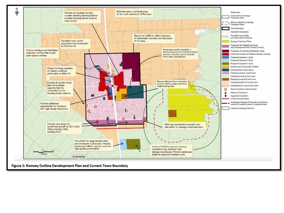
Figure 6: Romsey is surrounded by farming and rural living zones which have enormous potential to become net greenhouse gas sinks and biodiversity restoration precincts.
Farm land has enormous variation to achieve these outcomes but the farming zone adjacent to Romsey has amongst the highest potential in the state because soil quality is high, rainfall is moderate to high and reasonably reliable even with climate change, temperature is moderate to cool and most farms have little to no native vegetation much of it being cleared by early settlers. The lack of native vegetation surrounding Romsey is highlighted in Section 3, 1 which states “Majority of the township and surrounds has been partially cleared of native vegetation and highly modified since European settlement. …There is sparse cover of native vegetation across the Romsey area…”
Every hectare removed from the farming zone and rezoned for housing or industry reduces the Shire and state’s potential to halt climate change and reverse biodiversity decline. Under what circumstances does action to counter the world wide climate emergency take precedence over “Council’s endorsement of the Macedon Ranges Statement of Planning Policy in 2019 and State Government approval of this policy in late 2019 to grow Romsey into a Large District Town.”
The RSP addresses environmental issues in section 3.6.3 and in Figure 31 and specifically under Settlement Principles states: “Ensure land provision in close proximity to the town to future proof the town’s energy and water needs”. It makes no reference to land close to the town having any role to play in greenhouse gas abatement and therefore countering global warming. This suggests the authors or the Council or both have no understanding of how land use change on farms can counter global warming, figure 7.
The Council is ignoring its most effective readily available method for countering the climate emergency if it supports developing Romsey into a Large District Town as per Options 2 and 3 and Scenario 4.
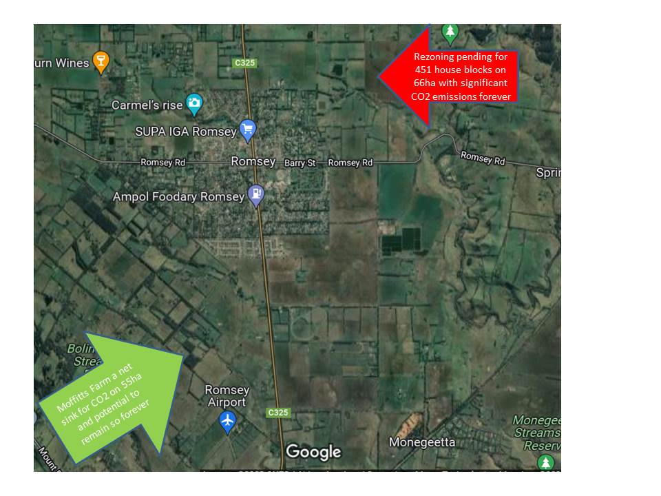
Figure 7: Depending on the decision taken by the current Council, Romsey and its surrounding farm land can become either a means for combating climate change by promoting farm land use change or be a contributor to global warming by converting farm land into housing estates with their corresponding ongoing greenhouse gas emissions.
Moffitts Farm two kilometres to the south west of the Romsey town boundary is a case study which demonstrates why preserving the farming zone and adopting land use change principles is so important for combating climate change. Over the last 36 years this 50ha settlers farm has been transformed from an ecosystem wasteland into a net CO2 sink to the tune of around 250tonnes CO2e per year, has restored biodiversity to the landscape, and contributes a range of other ecosystem services such as clean water in Sandy creek, figure 8.
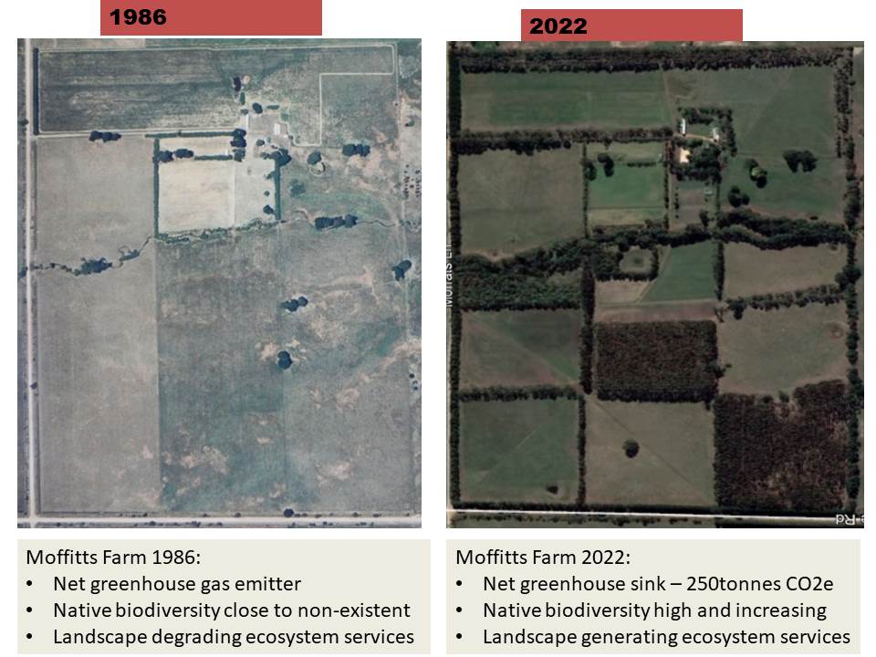
Figure 8: Moffitts Farm has seen a dramatic turnaround in ecosystem services it provides the community as well as being a productive red meat farming enterprise. Most of the farming zone land surrounding Romsey has the same potential to provide ecosystem services and counter climate change.
The draft RSP’s figure 33 indicates that up to 341ha will be rezoned for housing outside the current town boundary to accommodate Scenarios 4’s population increase to 10,000. That area is close to sacrificing seven Moffitts Farm worth of greenhouse gas abatement and ecosystem services improvements for more biodiversity decline and adding more greenhouse gases to the atmosphere.
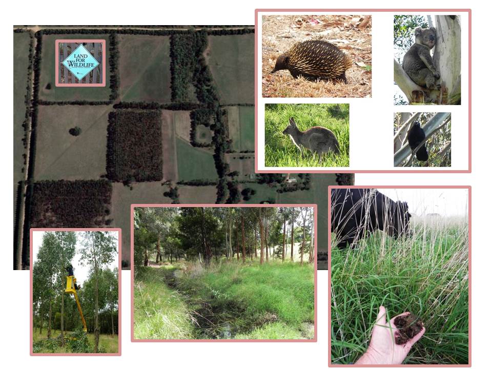
Figure 9: Retaining farming zone land around Romsey is an opportunity to counter climate change and restore threatened biodiversity as demonstrated on Moffitts Farm and other Land for Wildlife farms south west of Romsey.
An emerging component of changing farming zone land use is the growing recognition by governments that Australia has enormous potential to counter climate change and meet its Net Zero Emissions by 2050 target by encouraging farmers to adopt holistic management which embraces carbon sequestration in vegetation and soils while at the same time improving ecosystem services such as biodiversity enhancement, and higher water quality, figure 9.
The federal government has introduced pilot programs to encourage this multi-faceted approach to farm management, figure 10.
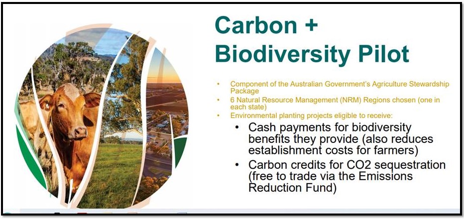
Figure 10: Governments are realising that farming is much more than production of food and fibre.
The National Farmers Federation chief executive Tony Mahar recently saidthe future of agriculture would likely be a dynamic farm system of multipurpose landscapes where traditional commodities like food and fibre contributed with maintained or improved attributes from carbon sequestration, biodiversity and other natural capital systems. A new era for farm land use is beginning and it needs as much high quantity carbon sequestration land as possible to be retained for the purpose. With this objective other ecosystem services will follow.

Figure 11: Macedon Ranges Shire knows it has a biodiversity crisis which it can combat alongside the Climate Emergency by retaining as much farm land as possible, or it can facilitate the crisis by rezoning high potential farming zone land around Romsey for residential and industrial uses.
The draft RSP carries no discussion around water supply for the four options despite the threat from climate change for more frequent droughts. There is no suggestion around all new houses being equipped with a 10,000 to 30.000litre rainwater storage tank (depending on house and block size).
When the next major drought occurs across south eastern Australia, where will the total population of Romsey on reticulated water source its water from? What information are potential new residents being given about water use restrictions in the next drought?
These examples suggest that the draft RSP is paying lip service to climate change without being prepared to address its implications across the four population and growth scenarios.
Conclusion: If the climate emergency and biodiversity decline are to be taken seriously in the Macedon Ranges Shire, then Option 1 is the only responsible option for the Romsey Structure Plan.
Protecting agricultural land to counter global warming not addressed
On page 8 the RSP states: “The Victorian Government has undertaken a review of agricultural land outside Melbourne’s urban growth boundary and within 100 kms of central Melbourne, consulting local governments, communities and stakeholders in this area. The entire Macedon Ranges Shire is located within this 100 km area identified as strategic agricultural land. ….Careful consideration of this agricultural
review is required before rezoning of any Farming Zone and Rural Living Zone land
around Romsey.”
Given this situation only Option 1 should be considered as appropriate for Romsey as Options 2, 3 and Scenario 4 all involve rezoning Farming and Rural Living land for urban and industrial uses.
It also needs to be pointed out that contrary to statements made by observers during the Romsey public meeting in mid-March, the soil type to the south, east and west of Romsey is high quality basalt clay loam with soil organic carbon levels from 3.5 to 5.0% which are amongst the highest levels in the state. When managed appropriately this soil can be highly productive given the moderate and relatively consistent rainfall and cooler summer temperatures surrounding Romsey, figure 12.
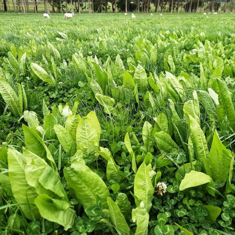
Figure 12: While most observers contend the red basalt soils to the north of Romsey are superior quality and should be protected from re-zoning, in fact the town is surrounded on the east, south and west by a different basalt soil which is also high quality but requires different plant species to achieve optimum production. In this photo in a basalt clay loam soil paddock just 2km south west of Romsey a suite of perennial clovers, the herb chicory and perennial ryegrass form a year round green pasture for high productivity livestock farming. This soil needs to be protected from re-zoning for housing and industrial developments.
Some observers suggest that the higher quality soil in the Romsey district is only located to the north between the town and Lancefield. This is also mentioned is section 3.1 This is a different basalt soil type which is free draining and traditionally recognised as having superior quality because of its ability to grow crops like potatoes and lucerne. It is incorrect to suggest that these soils are superior quality to black higher clay content soils to the south, they are different soil types with different characteristics and both have advantages for specific pastures species and crops.
To suggest that the black clay loam soils to the south, east and west of Romsey are inferior to the reds in the north is inaccurate. The point is Romsey is surrounded by high quality soils and so it should be maintained as farming land for future generations.
Conclusion: Romsey is in a unique position of being surrounded by farming and rural living zones encompassing high quality basalt soils. All farms surrounding the town have enormous potential to become greenhouse gas sinks and counter global warming while remaining productive areas for food and fibre. For these reasons Option 1 which retains the existing town boundary should be endorsed.